


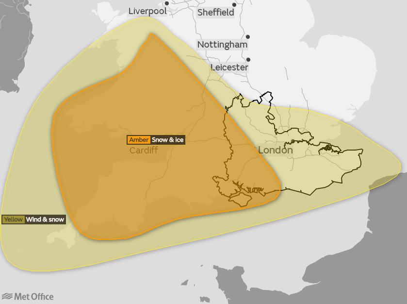
 The Met Office has issued an amber weather warning for snow on the Isle of Wight from 14:00 on Thursday afternoon.
Forecasters say that snow showers moving from the South could intensify and become heavy on Thursday afternoon and into the evening. As less cold air follows from the south, there is a chance of snow turning to freezing rain bringing an additional significant ice risk.
The heavy snow is likely to be accompanied by strengthening easterly winds which could cause blizzard like conditions.


Long delays and cancellations to public transport could occur, whilst some roads may become blocked by deep snow, stranding vehicles and passengers. Long interruptions to power supplies and other utilities could also occur.
There is still uncertainty in how this system will develop, but there is a chance that the combined effects of snow, strong winds and ice will lead to severe impacts. The amber warning expires 08:00 on Friday but a yellow warning remains in force until 23:55 on Friday.
Follow Island Echo for continued updates throughout the week… LIVE updates right here at www.islandecho.co.uk, on our Twitter @islandecho and on Facebook at www.facebook.com/islandecho.