


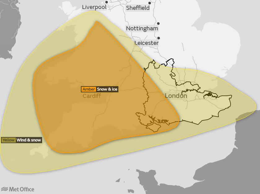
 Between 10-20cm of snow is expected to fall widely across the South of England and the Isle of Wight tomorrow (Thursday) – that’s according to the Met Office, who have upgraded their amber weather warning.
Snow will start to move in from the South under a yellow weather warning early on Thursday morning, but it is from midday that forecasters say the heavy snow will develop. Strong easterly winds are expected also, leading to the drifting of lying snow in places.
As less cold air follows from the South, there is a chance of snow turning to freezing rain in places as the evening turns to night, with widespread icy stretches forming making driving conditions dangerous.


Some rural communities could become cut off as a result of the adverse weather and interruptions to power supplies and mobile phone coverage are also possible.
Island Roads say they will be gritting on major routes at 22:00 tonight and again at 02:00 and 06:00. Treatment of pedestrian routes will take place in Newport, Ryde, Bembridge, Sandown, Shanklin, Ventnor, Freshwater, Yarmouth, Cowes, East Cowes and Wootton at 06:00 tomorrow morning.
Hampshire Constabulary are advising drivers across Hampshire and the Isle of Wight not to travel unless absolutely necessary.
Island Echo will be bringing you live updates throughout the day on travel, school closures and service changes right here at www.islandecho.co.uk.

The Met Office have upgraded their warning since yesterday to reflect the growing confidence of a severe spell of weather. The snow is now ‘highly likely’ with a ‘high impact’.