


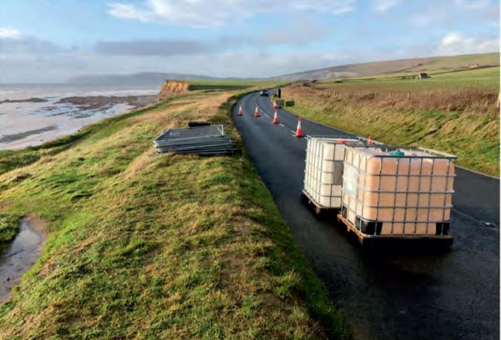

 Stabilising works are proposed for a section of the Military Road, with fears the section could be in danger of collapsing in just 7 years if no action is taken.
Plans have been submitted to the Isle of Wight Council by Island Roads to help remove any instability the section of Military Road between Brook and Hanover Point might face in the coming years due to cliff erosion.
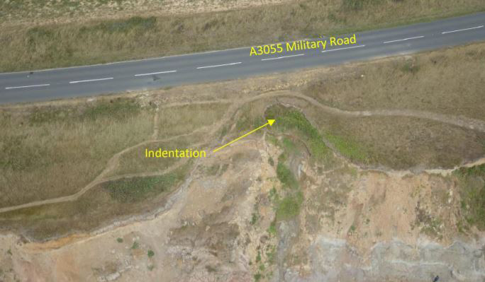
Currently, the 25-metre section of road is in danger of disappearing should there be more cliff movements — with some parts being 20m away from the cliff edge and others less than 5m.


According to planning documents, it is the section of the Military Road closest to the cliff edge, apart from Afton Down.
The proposed works would ‘isolate it from coastal cliff failure’ and ‘provide a short to medium term temporary protection scheme’.
26 piles would be bored into the ground, going 21m deep, with shallower piles between the big ones allowing the water to pass.
In the environmental survey, attached to planning documents, surveyors said at the rate of recession currently happening, the cliff edge would meet the road in as little as 7 to 8 years.
Action on the site is a specific requirement of the Highways PFI contract. The first option considered for the site was to build a bridged structure supporting the road instead, but it would not last as long.

The current scheme is the preferred option and documents say it could be future-proofed if necessary.
Planning agents said:
“Closure of the road is a real risk unless there is intervention that prevents the collapse of the carriageway.”
It is thought if the plans get approval, it would take eight weeks to complete but a road closure — potentially only part — would need to be put in place.
To view plans for the site and comment on the application (20/01281/FUL), you can visit the Isle of Wight Council’s planning portal.


The Island is getting smaller as portions crumble into the sea, yet thousands more houses are planned to be built here, taking up the naturally receding green areas we have left, and adding to the traffic which contribute to highway damage.
When one sees many mountainous regions around the globe where roads are carved around them in solid rock, it hardly seems a massive task to excavate into soft chalk and create a safer portion inland.
The dug out chalk could be used instead of destroying more of the downland as they do now at Arreton and Combley etc, thus limiting the sad loss of wild plants and life at the military road alterations.
Because of the costs involved in this work, surely it would be cheaper to buy a couple or five acres of land from whoever owns the adjacent ground and divert the road 25 years-worth of erosion inland. This could be built without closing the existing road and linked in at completion.
Edit: sorry, similar to what Joey above said.
It’s probably owned by the National Trust, if this is the case, they never surrender or sell anything
If it does neen stabilise work you need a proper company in to do the works. If island roads do it it will only last a extra year.
Rocks need to be placed along the foot of the cliff along all this stretch of the Island’s coast to prevent the sea eating away at the toe of the cliff.
Or the Floating Bridge!
As the article states, these plans are just a short to medium term solution and will not be cost effective. As a primary Island route, the Military Road deserves a better more strategic consideration based on slight re-routing options that will secure it for at least the next 100 years, rather than a patch job.
I avoid that particular section of the road now completely. They say it might take 7 years to collapse, but what do they know. The truth is, it could collapse at any time. Re-route it inland by a 200 metres.
don’t let island roads do it have you seen there work.