















































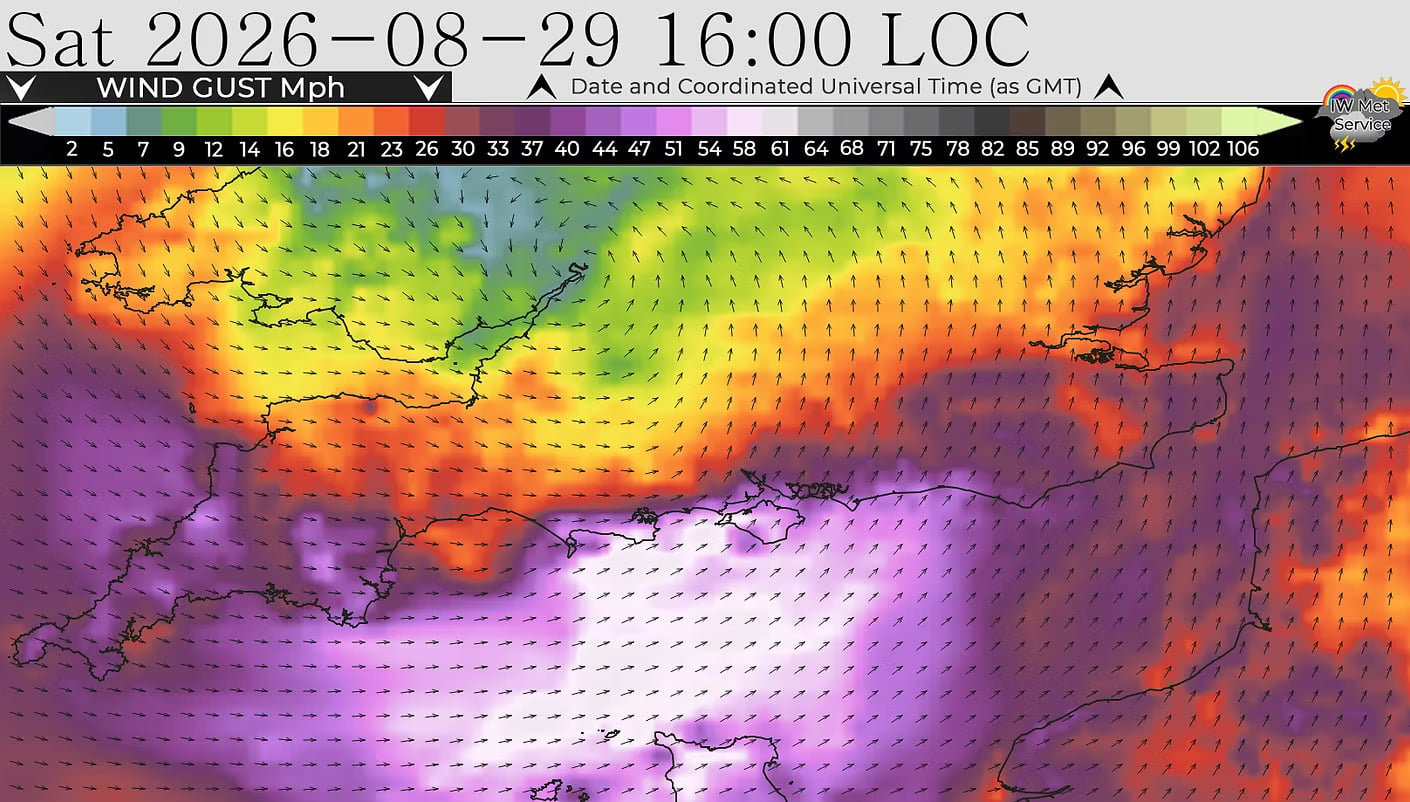
A yellow weather warning has been issued for the Isle of Wight with gusts of up to 60mph expected tomorrow (Saturday).
IW Met Service has issued the warning ahead of strong southwesterly winds developing across the Island during Saturday afternoon.
The warning will be in force from 10:00 until 23:00 on 29th August, with conditions expected to peak during the mid to late afternoon before gradually easing through the evening.

Forecasters say gusts could potentially reach 55-60mph in exposed locations, with speeds of around 45-50mph expected elsewhere.
A few slightly stronger gusts are also possible in and around squally showers, particularly over exposed hills and headlands.
Cross-Solent travel could be disrupted during the strongest winds, with delays or cancellations possible.
Outdoor events could also be affected, particularly those using temporary structures such as gazebos, marquees, signs and displays.

Large waves and some overtopping are possible around exposed coastal areas, particularly earlier in the warning period. People are being urged to take extra care around sea walls, promenades and exposed beaches.
The strong winds could bring down twigs, leaves and occasional small branches, while loose garden furniture and other outdoor items could be blown around.
Islanders are advised to secure trampolines, parasols, bins, garden furniture and other lightweight items before the winds strengthen.
Driving conditions could become difficult at times, particularly for high-sided vehicles and motorcycles, as well as motorists using exposed roads.





































Great…perfect weather for camping then
Such a shame for the scooterists
let’s hope the weather is better for the ride out on
Sunday.
Monday is nice ..
Can only thank the winds to overpower the noise produced by those little things. A kid on a VW would be stopped by the police for the noise of their exhaust. I don’t know why those Vespas get a pass
wow bet your a star and glitter explosion at parties?!”not”!
Oh get a life …
That’s me NOT going shopping in S’ton then!!
Are we going to have an alert and extreme weather news now ..
Let’s hope not, thankfully I dodn’t receive
the last one.
I am waiting for the alert that states there is going
to be a General election
If only would be like winning the lottery..get this shit out.
Don’t forget most of the s**t we’re in was caused by the previous government.